
Dictionary, Census of Population, 2016
Geocoding
Definition
Geocoding is the process of assigning geographic identifiers (codes or x,y coordinates) to map features and data records. The resulting geocodes permit data to be linked geographically to a place on the earth.
Households, postal codesOM and place of work data are linked to blockface representative points (coordinates) when the street and address information is available; otherwise, they are linked to dissemination block (DB) representative points. In some cases, postal codesOM and place of work data are linked to dissemination area (DA) representative points when they cannot be linked to DBs. As well, place of work data are linked to census subdivision representative points when the data cannot be linked to DAs.
Reported in
2016, 2011, 2006, 2001, 1996, 1991, 1986, 1981, 1976, 1971
Remarks
Statistics Canada's Custom Area Creation Service provides census data tabulations for user-defined areas, such as provincial electoral districts, local planning areas and school districts. When tabulating census data for user-defined areas, households are included or excluded depending on whether the representative points to which they are linked fall inside or outside the user-defined area (Figure 1.13). Thus, the data retrieved are most precise when user-defined areas coincide with dissemination block boundaries. Census data for individual blockfaces are not disseminated.
Figure 1.13
Example of data retrieval with user-defined boundaries
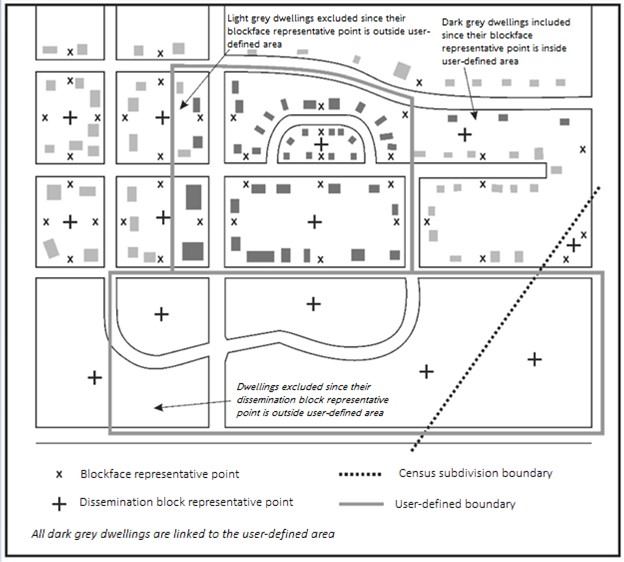
Description of Figure 1.13
Figure 1.13 is a graphic representation of the information that is used to create user-defined boundaries. Two user-defined boundaries are shown and are represented by thick grey lines. Each of these boundaries includes partial and complete dissemination blocks.
The illustration is made up of a fictional grouping of streets and dissemination blocks. Dissemination blocks appear as polygons. Each block contains blockface representative points, which are represented by a small 'x' and are centred on the inside of each blockface. Each block also contains a dissemination block representative point located in the centre of the block, which is represented by a large, bolded plus sign (+).
In the bottom right quadrant, two dissemination blocks are crossed diagonally by a census subdivision (CSD) boundary. In order to respect the dissemination area geography, the CSD boundary splits each of the dissemination blocks that it crosses, thus creating two dissemination blocks out of one. Each one of these dissemination blocks contains a dissemination block representative point located in its centre.
Most dissemination blocks in this diagram also contain a series of small polygons that represent dwellings, shaded light grey or dark grey. Dwellings that are shaded light grey represent those that are excluded from the data retrieval since their blockface representative point falls outside the user-defined area. Those that are shaded dark grey represent dwellings that are included in the data retrieval since their blockface representative point falls within the user-defined area.
Below the figure is a legend which demonstrates the symbols used in the figure to represent blockface representative points, dissemination block representative points, the census subdivision boundary, dissemination block boundaries and a user-defined boundary.
Source: Statistics Canada, 2016 Census of Population.
Refer to related definitions of blockface; census subdivision (CSD); dissemination area (DA); dissemination block (DB); postal codeOM; representative point and Spatial Data Infrastructure (SDI).
Changes prior to the current census
Prior to 2001, households, postal codesOM and place of work data were linked to enumeration area (EA) representative points when they could not be linked to blockface representative points. As well, unrounded blockface population counts were provided for user confirmation before tabulating characteristic data for custom areas.
- Date modified: