
Dictionary, Census of Population, 2016
Digital boundary files (DBFs)
Definition
Digital boundary files (DBFs) portray the boundaries used for census data collection and, therefore, often extend as straight lines into bodies of water.
Reported in
2016, 2011, 2006, 1996, 1991, 1986, 1981, 1976
Remarks
The boundaries of the geographic areas reflect those in effect on January 1, 2016 (the geographic reference date for the 2016 Census of Canada).
The boundaries are generated from the Spatial Data Infrastructure (SDI). The boundaries extend into bodies of water, rather than follow the shoreline, to ensure that limits are followed and that all land and islands are included for census enumeration. Thus, boundaries may cut through lakes, extend into oceans, or follow the approximate centres of rivers.
Digital boundary files are not suitable for computing land area, thematic mapping applications or other types of analyses requiring the realistic depiction of shorelines and water bodies, unless the user intends to apply their own shorelines to the boundaries.
The maps in Figure 1.4 below show the differences between cartographic boundary files and digital boundary files.
Figure 1.4
Example of a cartographic boundary file and a digital boundary file (provinces and territories)
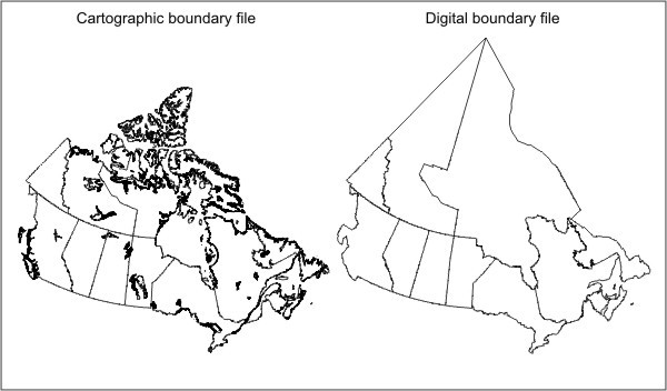
Description for Figure 1.4
Figure 1.4 shows two representations of Canada's provincial and territorial boundaries. The map on the left shows an illustration of Canada as it appears in a cartographic boundary file. It is a detailed representation of Canada's land masses (including islands) and shorelines. Internal bodies of water, such as lakes and rivers, are also shown.
The map on the right shows a map of Canada as it appears in a digital boundary file. It is a generalized illustration of Canada's boundaries. Each province and territory is represented by a single polygon, thus the boundaries extend into bodies of water, rather than follow the shoreline. As a result, boundaries may cut through lakes, extend into oceans, or follow the approximate centres of rivers.
Source: Statistics Canada, 2016 Census of Population.
Refer to the related definitions of cartographic boundary files (CBFs); road network file (RNF); Spatial Data Infrastructure (SDI) and to the Boundary Files, Reference Guide (Catalogue no. 92-160-G).
Changes prior to the current census
Not applicable
- Date modified: